Showing posts with label Open Source. Show all posts

Thursday, July 21, 2011

World Wind Java SDK Web Site

All you want to know about the World Wind Java SDK is here:
http://goworldwind.org/

Friday, July 15, 2011

World Wind Java SDK 1.2 Announcement

From the WWJ SDK Developement team:

"On Tuesday July 19th, 2011 we are releasing World Wind 1.2. Please join us that day for the webinar, where we'll describe the release contents and the new resources available to help and guide World Wind developers. We'll also discuss World Wind's near-term road map. There are sessions for American and European time zones, There are only 100 spaces available per session, so sign up soon, but please don't sign up if you are unlikely to attend.

Register for a session now by clicking a date below:

Tue, Jul 19, 2011 4:00 PM - 4:45 PM CEST
Tue, Jul 19, 2011 10:00 AM - 10:45 AM PDT

Once registered you will receive an email confirming your registration with information you need to join the Webinar."

Tuesday, March 16, 2010

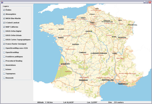
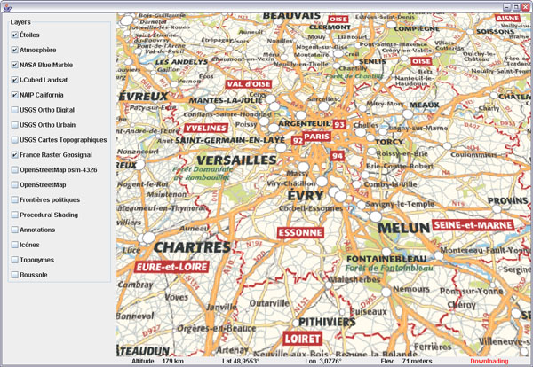
French Geoportal's layers published using NASA World Wind

Nice surprise today, the French Geoportail is publishing it's layers content via a new World Wind Java application available online.

Some screenshots:

French Geoportail and NASA World Wind JavaFrance map


French Geoportail and NASA World Wind JavaParis area


French Geoportail and NASA World Wind JavaTopo maps over Mercantour National Park


French Geoportail and NASA World Wind JavaRoads, shoreline and buildings over aerial imagery


French Geoportail and NASA World Wind JavaColored DTMs - French Riviera and the Alps

I was secretly hopping this to happen and i'm very pleased to see the move has taken place so soon. However, it is still unclear whether the actual Geoportail 3D client using Skyline TerraExplorer will be replaced with a Java version using WWJ...

Monday, January 18, 2010

Textured Wall for World Wind Java

Following up on a WWJ Forum post regarding a 'vertical image' to display atmospheric data, i quickly put together a simple renderable that will draw an image on a plane perpendicular to the globe surface.

Textured wall for WWJ
Download TexturedWall.java - remove the .txt extension and save in the SDK render package.

Nothing fancy, really, a texture rendered over a quad - it will not 'curve' around the globe on long distances. The quad is defined with two LatLon locations, a bottom and a top altitude. It is also an example of a simple renderable using OGL primitives that may serve as a base template for more sophisticated objects.

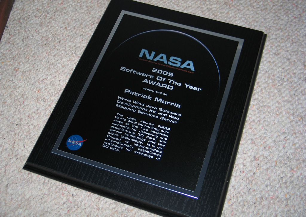
NASA Software Of The Year 2009 Plaque

Happy 2010 to you all! - and plenty of virtual globes!

Sorry for posting so little lately... the World Wind Java SDK is keeping the team very busy. I also lost my father last summer.

I should certainly post a review of what has changed in the WWJ SDK since the nightly builds and 0.6 have been made available (was it last March?!) and i'm hopping to do that soon.

In the mean time i'm proud to show you the beautiful plaque i received from NASA, almost for Christmas. It is surprisingly heavy!

Thursday, November 5, 2009

World Wind Java selected for the 2009 NASA Software Of The Year Award

The NASA Software Advisory Panel has selected the World Wind Java SDK for the 2009 NASA Software Of The Year Award.

World Wind Java 2009 NASA Software Of The Year Award
See this World Wind Forum post for the announcement by Project Manager Patrick Hogan at Ames Research Center.

This is great news for the free and open source project which will certainly receive increased attention from the other departments of the space agency - and beyond. World Wind was initiated by NASA Learning Technologies in 2002.

Sunday, April 5, 2009

Sunlight package for WorldWind Java

Here is the very first iteration of a sun light package for NASA WorldWind Java. It includes a custom tessellator for terrain shading, an atmospheric scattering based sky layer, a sun position calculator and a lens flare effect. Some of the code has been contributed by WWJ Forum member Michael de Hoog aka Omega.

Sun shading in WorldWind JavaTerrain shading

Download the sunlight package (Zip 33K). Unzip in the SDK examples package and run the sunlight.SunShading.java demo application.

Lens flare and atmospheric scattering in WorldWind JavaLens flare and atmospheric scattering

The demo application code will show you how to use the different components. Although this initial version works rather well, you may notice a couple issues. Dark or bright bands may show across the terrain in some places. The atmospheric scattering code is not optimal. It fails to produce a blue sky at ground level and the sky underlying geometry is too coarse to produce nice and smooth sunsets. The sun calculator reported position does not seem right either.

Lens flare and atmospheric scattering in WorldWind JavaSun occlusion


Enjoy!

Friday, March 6, 2009

WorldWind Java 0.6 Source available

Access to the daily NASA WorldWind Java SDK 0.6 source code has been made public from the NASA WWJ build site. You will find the announcement and change list in this WWJ Forum post.

So much has been going into the SDK since the 0.5 release in May 2008 it is hard to sort out what the most notable changes and additions are. Here are a number of new features that come to mind.

WWJ 0.6 Airspace volumesAirspace volumes


WWJ 0.6 Airspace builderAirspace builder

You will find a new render.airspace package you can see at work with the examples.Airspaces application. It includes a number of geometric volumes that can follow the terrain. It's main application is to visualize 'air spaces' but there is no doubt it will serve many other purposes. Be sure to have a look at the AirspaceBuilder that allows you to create and edit 3D polygons and spheres.

WWJ 0.6 On-screen layersOn-screen layer manager, status bar and view controls

There are a couple new on-screen layers that replace the status bar and layer manager SWING version and offer control over the view. All the 2D layers have now a 'location offset' property that let you fine tune their screen placement.

WWJ 0.6 Contour linesContour lines

The default tessellator has been augmented with intersection code for line and elevation against the current terrain geometry. This allows to cast rays or compute contour lines that you can see at work in the examples.ContourLines.

WWJ 0.6 Rubber sheet imagesRubber sheet images

At a lot of work has been done on data import and image processing. There is code to import, manipulate, tile, stitch and transform imagery. You will find surface textures you can stretch and warp with the examples.RubberSheetImage application.

The icon layer and renderer can now use absolute elevations and will perform horizon and view frustum clipping if set to do so. This should help handle larger icon populations.

Work has been done to allow several elevation models and data sources to be compounded.

WWJ 0.6 Measure toolsLength and area measure tools

Interactive length and area measure tools have been added - see examples.MeasureToolUsage and util.measure package.

Tiled image layers can now use mipmaps and produce a cleaner terrain rendering without 'shimmering' in the distance. Image blending has been fixed and should allow proper application of semi opaque layers without the 'black edges' we have seen before. However this change had the fog produce 'white edges' so it has been dropped for now - the fog layer.

The applet package has been updated to take advantage of the latest Sun Next Generation Java plugin - more stable and flexible.

WWJ 0.6 Multimedia annotationsMultimedia annotations

A new examples.util package contains a couple useful tools like a browser launcher, an image viewer, an audio player or a slide viewer.

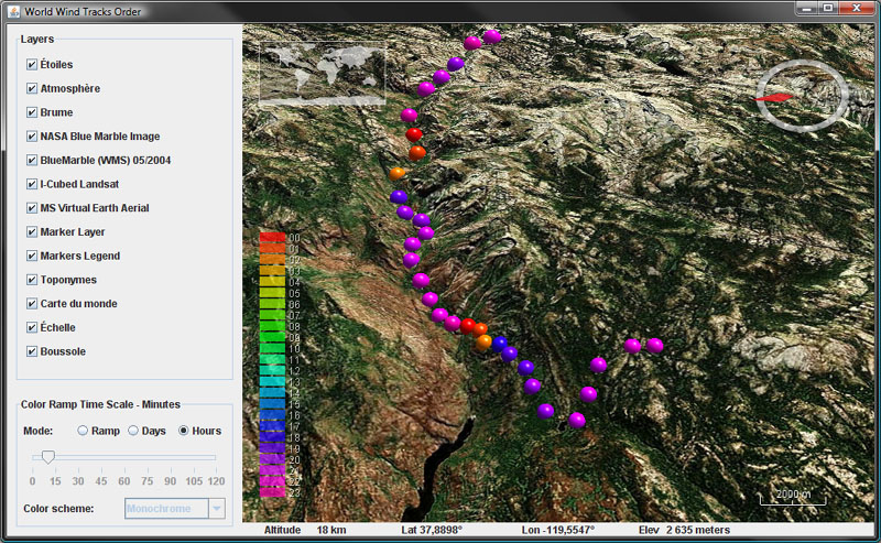
The view sensitivity can now be set. The TerrainProfileLayer can now follow a path. Track markers have been reworked and have now extended and more flexible capabilities. The FlatWorld example has been updated with code to switch from round to flat globe. The place name layer has been enhanced. Web Service Catalog support has been implemented - see applications.gio. There is code to convert WW.net cache...

Many bugs have been fixed, often in response to comments from the World Wind Java Forum users. Thank you all.

More screenshots dating back to October 2008 can be found here.

For all migration related issues, questions and comments, please use this WWJ Forum thread.

Saturday, January 24, 2009

Interview with Patrick Hogan WWJ Project Manager

Patrick Hogan is NASA World Wind Project Manager. He was kind enough to answer and comment ten questions regarding NASA virtual globe project and open source initiative.


Patrick Hogan at NASA Ames Research Center
1. World Wind came out in 2004 before Google Earth and is arguably one of the (if not the) first virtual globe. What is the 'short' history of World Wind - how and when did it all start, what where the goals and the context?


World Wind began in the 2002/2003 timeframe under NASA Learning Technologies, a program to get 'NASA content' into the classroom. In January 2004 World Wind became one of the first NASA programs to be released as open source. World Wind existed approximately coincident with Keyhole, though neither knew of each other until later.

2. World Wind is a free and open source project delivering technologies to the community that some private companies have spent large amounts of money to acquire. Who is paying for this and how come it’s given away just like that?

Same answer as to your previous question, World Wind began as part of NASA Learning Technologies, a program to get 'NASA content' into the classroom. NASA has more planetary information than any other entity on Earth. NASA, more than any other entity on Earth, needs to have the tools necessary to work with planetary data that is part of the public domain. Today, more than ever, it is vital that research, academia and the public have useful access to this data. This is made most possible with technology that can readily adapt to service those various needs. This includes the need for a broad spectrum of private companies who are free to use this technology in proprietary ways. World Wind open source technology stimulates entrepreneurial enterprise by helping to standardize the geospatial information exchange medium. This establishes the infrastructure for greater participation by the widest possible range of business enterprise from small to large.

The World Wind project is supported by several agencies within the US federal government, including of course NASA.

By using open source technology and open standards for data exchange, the government has the ability to adapt to rapidly changing circumstances. Building increasingly more sophisticated functionalities to a core technology that is open source continually challenges entrepreneurs and the world community to greater appreciation for what is possible. NASA provides the kind of leadership that allows for this. World Wind technology also provides the government with absolute control over use of the technology, as well as absolute security due to code visibility, while also making industry and the world community more competitive in the area of solutions based on use of this open and standardized technology. These solutions can be proprietary, free, or open. Advances in intelligence come from a combination of information access and increasingly sophisticated processing of that information. World Wind, although a very smart mechanism, is not intelligence. World Wind technology is about standardized and optimized delivery of pixels, picking them up and moving them around. Information intelligence is applied by others using this technology as the medium for information exchange, a lingua franca, if you will.

3. A common reaction to the World Wind project is to wonder why bother redeveloping something that already exist for free, namely Google Earth or Microsoft’s Virtual Earth?

Google, who bought Keyhole in October of 2004, delivers data that is proprietary and restricts use of its technology essentially to the KML file format. World Wind provides that same ability without any limitation on how one might use the technology. This stimulates business opportunities for a much larger solution domain.

4. It is a bit disappointing that one cannot access imagery as good as in other virtual globes with NASA software. Why is it so?

When you open World Wind, out of the box so to speak, it arrives with the base set of data needed for a 3D world. Although higher quality imagery is available that World Wind can certainly deliver, and does so for those who have access to that data, the base set of data that World Wind comes with is necessarily in the public domain. We are looking forward to higher quality imagery becoming increasingly more available. We are already seeing this happen. The great State of New York and the great country of New Zealand, having made higher quality imagery publicly available, prove this is already happening.

5. There does not seem to be any 'road map' for the World Wind Java SDK. How are decisions made regarding the implemented capabilities?

For those who can appreciate the degree of sophistication involved in developing an Application Programming Interface (API) -centric Software Development Kit (SDK), it’s easy to understand the unusual amount of *accommodation* required for how others will use the technology. Building an optimized and adaptable technology of this nature is a Herculean task. It is far more involved than simply building an application. World Wind technology must transparently 'plug-in' to other applications. The ability to do that well is as much art as engineering. Leonardo da Vinci was notorious for spending inordinate amounts of time working through ideas before ever putting paint to brush. World Wind is being crafted as an adaptable building block others construct with. Making it work requires accounting for many variables well beyond our control. Building for the future is an infinite challenge. We look forward to a time when much more of the world participates in the development. Although this is already happening informally, this will begin in earnest with release of v1.0.

6. How large is the development team?

I’ve heard it said that it’s not size that matters. So thankfully, we have a few of the best. At some point, after version 1.0, we’d like to see a collaboration of the world community to advance this core technology. We’re already seeing this technology applied by the European Space Agency, the Japan Space Agency, and a few Fortune 100 companies, as well as extensively within the US government.

7. A number of community users would be willing to contribute code to the project but there is no such established process to do so now. Are there any plans to allow contributions?

We welcome contributions and have already put some of those to good use. We want World Wind development in the hands of a well organized worldwide consortium. That takes a concerted effort by the world community. We look forward with great anticipation to that stage of this project. You don't have to be a rocket scientist to know that the amount of energy required to effectively process the input from a worldwide community is enormous. 2009 should be 'the' year for version 1.0 of World Wind along with the hope for a world community that hosts the ongoing development of this technology.

8. The WWJ SDK is still in alpha stage after two years. When can we expect a stable 1.0 release and what will be in it?

In the spirit of ‘we will serve no wine before its time,' version 1.0 is expected during the second half of this year (2009). What will be in it? More and better stuff!

9. The WWJ SDK departed from the World Wind .NET version in the sense it is not a 'ready to use' client application one can download and use right away. Although there are clear advantages in providing a SDK, are there any plans to produce a WWJ client application similar to the .NET version so many have been using?

World Wind Java is component technology purposed to be used as a plug-in by others in support of their visualization needs. We like playing a strong supporting role rather than the lead. We believe this provides the maximum opportunity for information exchange technology to advance.

10. The unique aspect of World Wind technology is that it also provides the WMS server software to deliver geospatial data. How did that happen?

World Wind SDK technology is there to visualize geospatial data, manage the pixels so to speak. Having the technology to see 3D is cool, but that's only half the story, maybe even the smaller half. Making data accessible, the data delivery mechanism, is where the information experience begins. The World Wind Server delivers data according to the Open Geospatial Consortium international WMS standards.

Together, the World Wind SDK client and WMS server provide the infrastructure for government, research, and business communities, as well as education and public outreach, to both deliver and experience information, hopefully increasing our understanding. And it is also true that sometimes we do things just for fun! World Wind technology unlocks the power to make all this happen.

Patrick Hogan - interview by Patrick Murris, January 2009.
Photo from swissstartups.com.

> Another Patrick Hogan interview by Scott Swigart, and Sean Campbell for the How Software is Built blog - July 2007.
> World Wind presentation at the Geological Society of America, May 2007. How the Java SDK got started.

Wednesday, December 3, 2008

World Wind at the American Geophysical Union

Patrick Hogan the NASA World Wind project manager will be presenting the World Wind Java SDK at the 2008 American Geophysical Union Fall Meeting in San Francisco December 15-19.

Although Google Earth and KML have an overwhelming presence, the World Wind Java SDK is being used by an increasing number of professionals:

Patrick Hogan presentations:

During Patrick's presentation, VEGA will also show a new version of EOLI (Earthnet OnLine Interactive), a client developed for the European Space Agency for the Earth Observation, Multi-mission, Catalogue and Ordering Services, using the World Wind SDK.

Thursday, November 20, 2008

World Wind Multitouch Wall in Public Underground

Johannes Schöning from the University of Muenster Institute for Geoinformatics, Germany has posted a video showing their multitouch wall version of World Wind Java installed in a public place.


During a technology exhibit we installed a FTIR based large scale multi-touch screen in pedestrian underway in the city of Münster, Germany. In this video we show a few impressions of this project called: "Hightech Underground".

Build your own multi-touch screen - see link below
See this previous post about the same multitouch World Wind project - May 2008.

> YouTube video here.
> Some pictures of the event.
> Build your own multitouch screen with the MultiTouch Bootcamp.
> Improving interaction with virtual globes through spatial thinking: helping users ask "why?", a research paper from the same author.

Tuesday, October 7, 2008

World Wind Java 0.6 Screenshots

While the next alpha 0.6 version of the NASA World Wind Java SDK is not ready yet, here are some screenshots showing some of the coming features.

NASA World Wind Java SDK 0.6
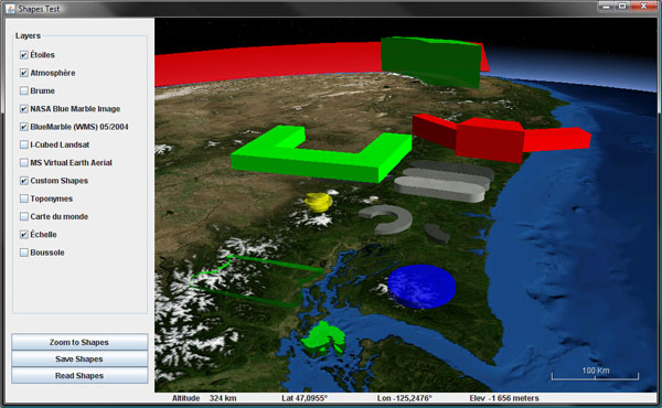
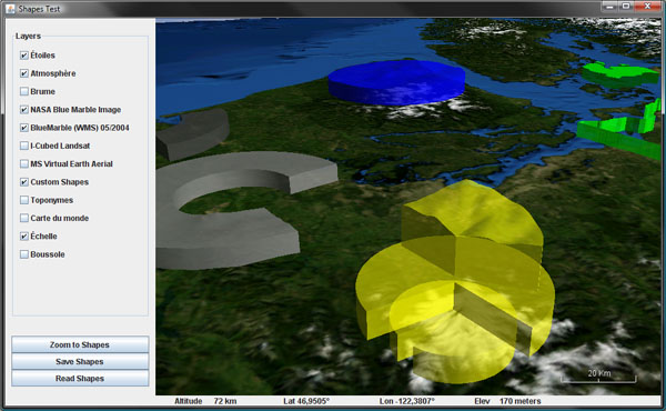
NASA World Wind Java SDK 0.6Airspace shapes and volumes, terrain conforming or not.
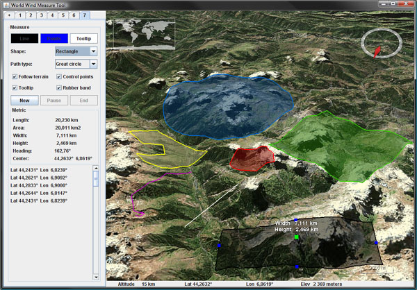

NASA World Wind Java SDK 0.6Distance and area measure tools, terrain following or not.
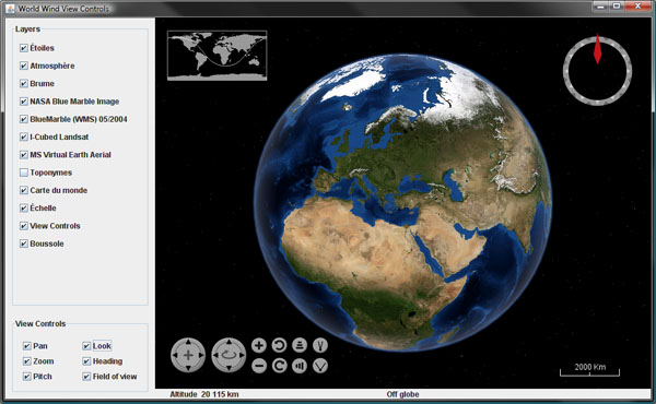

NASA World Wind Java SDK 0.6View visual controls layer, provides a GUI to pan, tilt, zoom or look around.

NASA World Wind Java SDK 0.6
NASA World Wind Java SDK 0.6Extended track markers shapes and attribute management.

Friday, September 12, 2008

Elevated Surface Image for World Wind Java

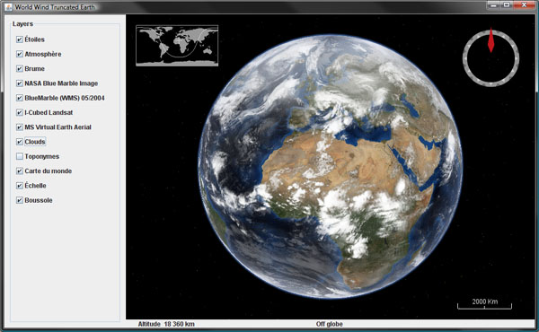
A few WWJ forum members have asked whether it would be possible to have a surface image that could be rendered somewhat 'up in the air' instead of painted on the globe surface. The idea would be to show the global clouds image for instance at 10 km altitude. Although the feature is not part of the actual SDK, i happen to have created some time ago a sub class of SurfaceImage that does exactly that.


Download TexturedLayer.java (updated for WWJ 0.6 December 7, 2009), remove the .txt extension and add to the SDK render package.

The class is very similar to SurfaceImage and is instantiated the same way, but the texture will be painted on a 'flat layer' at a given altitude that must be set using the setElevation() method.

Note that the cloud image does not contain an alpha channel and will obscure the underlying imagery. In the .net version of World Wind, the "Global Clouds" plugin does some post processing after each new image is downloaded to create an alpha channel and save the resulting image as a .png. In that case the alpha is just a copy of the black and white cloud image.

However, i found you could get somewhat better results by replacing the cloud image with plain white - the alpha channel will then 'modulate' the white and produce a more realistic effect without the 'grayish' shades where the cloud coverage is less then one hundred percent.

The bottom line is that some additional work is to be done to get a decent global cloud image over the World Wind Java globe, even with this 'elevated' surface image class. The above screenshot is using a static post processed image - not the 'real time' online version.

Another usage of this textured layer could be to use a plain blue texture with some transparency and somewhat simulate the sea level as with the "Global Flood" WW.net plugin (see this forum thread).

Monday, September 1, 2008

Truncated Earth in World Wind Java

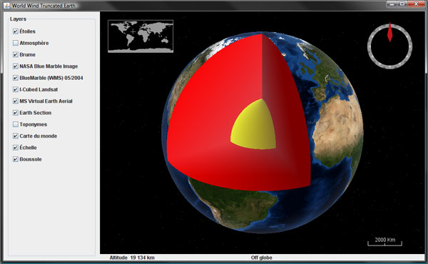
I wanted to try this for a while and i'm pleased to see it works rather well considering how little code is involved. Here is a simple World Wind Java example application that will produce a truncated globe.


Download TruncatedEarth.java, remove the .txt extension and add to the SDK examples package.

Update Nov. 20: once again there appear to be a dependency on the not yet publish SDK 0.6. Please check this forum post for a workaround with version 0.5.

The code illustrates how to extend and override the globe elevation model to 'take out' a slice of the planet. Although rough coloring of the section interior is easily done with some gradients and surface images, placing a texture on the section side would require a bit more then that.

Saturday, August 2, 2008

OneGeology World Layer for World Wind Java

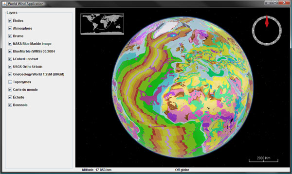
Did you ever wonder what the Earth would look like if you stripped it of water and vegetation, revealing the underlying rocks?

The OneGeology project aim is to create dynamic digital geological map data for the world. It is an international initiative of the geological surveys of the world who are working together to achieve this ambitious and exciting venture.


Here is a WMS layer for NASA World Wind Java showing the 1:25M Geologic Units for the entire planet, provided by the french BRGM. Download OneGeologyWorldLayer.java, remove the .txt extension and add to the SDK layers.Earth package. Note that this layer is only a coarse 'preview' of the underlying datasets and will not yield much details if you zoom closer.

The OneGeology web site features a 2D map browser - the OneGeology Portal, that allows you to explore in more details the different layers provided by the participating organizations.

The official launch of OneGeology will happen at the 33rd International Geological Congress (IGC) in Oslo, August 6th - 14th 2008.

See this Nature article for an overview of the project.

Tuesday, June 3, 2008

World Borders alternate layers for WWJ

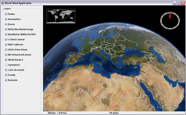
The 'broken' Country Boundaries layer has been an issue for some time in World Wind Java... After a quick search, here are three alternate layers to fill the gap until the NASA WMS server gets up and running again.

Metacarta country_02 layer - 12 levels, no coastline - WorldBordersMetacartaLayer.java
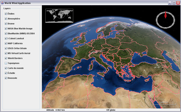

Freemap factbook layer - 12 levels, not so clean - WorldBordersFreemapLayer.java

Katrina OWS world layer - 5 levels only - WorldBordersKatrinaOWSLayer.java

Friday, May 9, 2008

JavaOne 2008 World Wind Java presentation slides

The JavaOne 2008 Power Point presentation for World Wind Java is now available.

World Wind Java presentation slides for JavaOne 2008
You will find some interesting bits about the new WMS server included in the SDK release 0.5.

Thursday, May 8, 2008

World Wind Java On a Multi-Touch Wall

Almost a year after the first World Wind Java SDK release in may 2007, a number of applications have emerged and have been gathered on the WWJ demo page. Whether it be for exploring the ocean depth, controlling cameras flying in the sky, tracking satellites or visualizing information clusters, WWJ is indeed showing up in a wide range of activities.


a


The University of Muenster Institute for Geoinformatics has now used WWJ for a multi-touch wall project. From Johannes Schöning IFGI:

"We developed a Multi-Touch version of Nasa World Wind on a 7.9 x 6.2 feet tall FTIR (frustrated total internal reflection) based Multi Touch wall. This implementation is based on a multi-touch tracking library developed within the Project: Multitouch at the Deutsche Telekom AG Laboratories, which is part of the TU Berlin."
Videos can be seen on YouTube or Google Video.de.

Friday, May 2, 2008

NASA World Wind Java SDK 0.5 released

NASA World Wind Java SDK alpha 5 - 0.5.0, has been released today. It has been five month since the previous 0.4 last december and a lot has been done since. However, although a 1.0 was in the plans, a lot remains to be done for the first stable version and you may not find all the fixes you wished for yet. Download WWJ SDK 0.5 (Zip 14.4M).

Among the most notable changes, my favorite is the new view handling which allows you to navigate with much more precision over elevated terrains as well as underwater. What is really nice is that you can now get very close to the ground and the 'orbit center point' is always anchored where you would expect, on the surface, in the middle of the viewport.

WorldWind Java 0.5Mount Rainier and Spirit Lake from inside Mount Saint Helens crater, WA, USA.
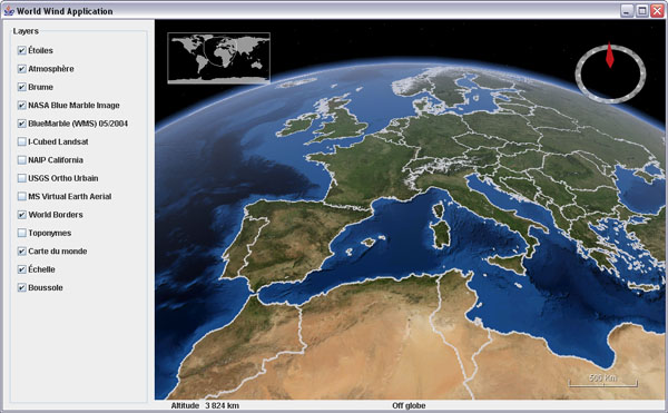
A lot of work has been done on the server side of the project. A free and open source WMS server is now included with the SDK, which itself has been deployed on a much faster network. Both Blue Marble Next Generation twelve month and I Cubed Landsat are now served via this new WMS infrastructure. Other datasets will be integrated, some 1m US NAIP among them.

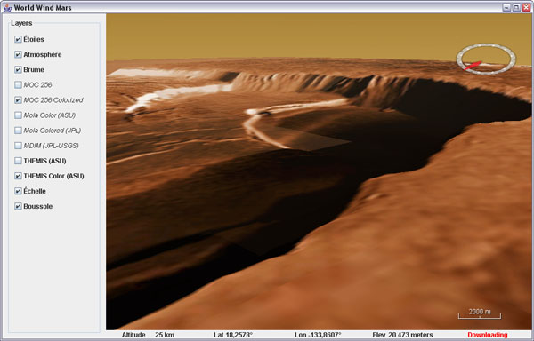
Mount Olympus crater, Mars, THEMIS Color layer
As expected, you will find the Moon and Mars globes with their full layer sets from the NASA servers - Mars data seems slow to download these days though.

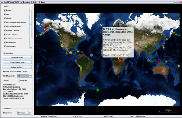
WorldWind Java 0.5 - Flat WorldsLast 7 days USGS earthquakes on Mercator world
Flat worlds with projection switching are now ready for prime time - or so we hope. You will find a new example application showing the latest USGS earthquakes over a Mercator world - or a modified sinusoidal if so you wish.

A 'Restorable' interface has been added and implemented in a number of classes. Think of it as a form of serialization, it allows to save an object state in an XML document and back. For instance, you can now easily save the view state - eye position, zoom, pitch angle, heading... in one step as a text string and restore it as easily.

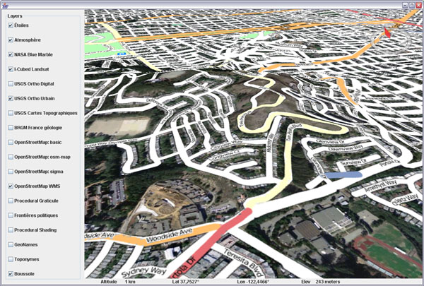
World Wind Java 0.5 - Open Street Map layerOpen Street Map layer over San Francisco, CA, USGS Urban Area layer
These are just a few of the many goodies you will discover inside this release. Tiled image layers have been fixed and will not wait anymore for lower res tiles to download before showing the needed ones. There is a 1 meter NAIP layer for California which is quite crisp, the Open Street Map layer, a rather complex MGRS graticule layer, new minimize/maximize buttons in the terrain profile layer graph... Surface images from a remote http source, faster polylines and more.

Be aware that some classes have been moved around. For instance, all non Earth specific layers have been moved from layers.Earth to layers - that involves FogLayer, ScalebarLayer, SkyColorLayer, SkyGradientLayer, StarsLayer, TerrainProfileLayer and WorldMapLayer.

Check this WWJ Forum post for a change list and discussion, see the new WWJ Demo page for webstart examples, applets and user applications, and go to World Wind Central for everything else. Enjoy!

Sunday, April 20, 2008

Geosignal French maps in WWJ

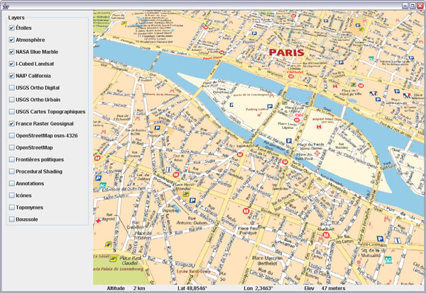
Toulouse based Geosignal has made freely available for more than a year a number of interesting layers on their WMS server. Here is a layer class for WorldWind Java that will bring together eight levels of details from the RASTER maps serie.

Geosignal French maps in WorldWind Java
Download GeosignalRasterWMSLayer.java, remove the .txt extension and add to the SDK layers.Earth package.

Geosignal French maps in WorldWind Java
The layer covers continental France and Corsica. The finest levels include street maps for most urban areas.


Geosignal French maps in WorldWind Java