Loading WW image layers in WWJ
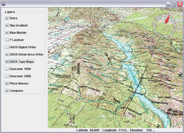
Here is a very first shot at a WW 'layer loader' for WWJ. It can create tiled image layers from a World Wind XML layer definition. No WMS yet. The screenshot shows a portion of the USGS Topo Maps layer - some shading would help though...
Download WWJ_WWXMLLayer_01.zip (5k) and follow instructions in the readme.txt to add new layers to the BasicDemo application. The layer definition will look like that :
I'm not sure WWJ likes it too much... it works but downloading seems chaotic. Maybe the servers are slow...
Download WWJ_WWXMLLayer_01.zip (5k) and follow instructions in the readme.txt to add new layers to the BasicDemo application. The layer definition will look like that :
private BasicDemo.LayerAction[] layers = new BasicDemo.LayerAction[] {
 new BasicDemo.LayerAction(new BMNGSurfaceLayer(), true),
 new BasicDemo.LayerAction(new LandsatI3(), true),
 new BasicDemo.LayerAction(new USGSDigitalOrtho(), false),
 new BasicDemo.LayerAction(new USGSUrbanAreaOrtho(), true),
  new BasicDemo.LayerAction(new WWXMLLayer("WW_Images.xml",
   "USGS Topo Maps"), false),
  new BasicDemo.LayerAction(new WWXMLLayer("WW_Images.xml",
   "Geocover 1990"), false),
  new BasicDemo.LayerAction(new WWXMLLayer("WW_Images.xml",
   "Geocover 2000"), false),
 new BasicDemo.LayerAction(new EarthNASAPlaceNameLayer(), true),
 new BasicDemo.LayerAction(new CompassLayer(), true),
};
I'm not sure WWJ likes it too much... it works but downloading seems chaotic. Maybe the servers are slow...


2 comments:
Works well for me - and reminds me of the old plastic cards that were hang at the wall in my primary school ;-)
-- pardon: plastic "maps" ---
Post a Comment